

The following Top 10 of natural disasters which were caught on camera took hundred thousands innocent peoples lives and led to damages worth billions of dollars.
Twitter: https://twitter.com/_PhotoCollector
Twitter: https://twitter.com/WildBaws
Photo number 10 (“Haiti Earthquake”)
A magnitude 7.0 earthquake that has a depth of 8.1 miles rocked Haiti on January 12, 2010. Its epicenter was located just south west of Port-Au-Prince with 59 aftershocks ranging from 4.2 to 5.9 magnitudes in strength. The strongest earthquake to hit the country since 1770, it had led to over 200,000 deaths, 2 million homeless, and 3 million people in need of emergency aid. At least US $195 million have been given with another US $120 million pledges from different countries, along with a large number of aid workers to help with rescue operations.
Photo number 9 (“Hurricane Katrina”)
The deadliest hurricane to hit the Gulf Coast in 2005, it was ranked as the sixth strongest overall to hit the United States. It was also one of the costliest with estimated property damages of US $81 billion.
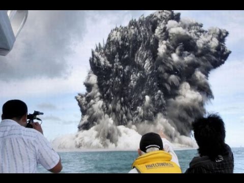
Photo number 8 (“Undersea Volcano – Tonga”)
The 2009 Tonga undersea volcanic eruption began on March 16, 2009, near the island of Hunga Tonga, approximately 11 kilometres from the Tongan capital of Tongatapu. The volcano is in a highly active volcanic region that represents a portion of the Pacific Ring of Fire. It is estimated that there are up to 36 undersea volcanoes clustered together in the area.
Photo number 7 (“Yangtze River Floods”)
When torrential rains hit southern China in August 1931, it caused the Yangtze River to flood killing nearly 3.7 million people. This was considered the worst natural disaster of the 20th century.
Photo number 6 (“Tsunami”)
A 9.0 magnitude quake followed by tsunami waves hit the east coast of Japan in March 11, 2011. With a depth of 24.4 km, this was the largest earthquake to ever strike Japan in recorded history. Documented as the 7th largest earthquake in the world, it led to about 15 million dead or injured, and 2,814 people missing. It also affected 18 prefectures, with over 250,000 buildings damaged or destroyed and caused a near nuclear disaster when there was a partial meltdown in 3 reactors of the Fukushima nuclear plant, which is the 2nd largest nuclear disaster after Chernobyl.
Photo number 5 (“East Africa Drought”)
From the year 1981 to the year 1984, the continent Africa was suffered because of the drought, which taking place in the twenty nations. More than 20,000 people starved to death because of that. Also, the rivers and lakes dried up because of the drought.
Photo number 4 (“Chaitén (volcano)”)
Chaitén is a volcanic caldera 3 kilometres (2 mi) in diameter, 17 kilometres (11 mi) west of the elongated ice-capped Michinmahuida volcano and 10 kilometres (6 mi) northeast of the town of Chaitén, near the Gulf of Corcovado in southern Chile. The most recent eruptive phase of the volcano erupted on 2008. Originally, radiocarbon dating of older tephra from the volcano suggested that its last previous eruption was in 7420 BC ± 75 years. However, recent studies have found that the volcano is more active than thought.
Photo number 3 (“Forest Fire – Dolginino, Russia”)
Firefighters are battling forest fires across western and central Russia in the worst heatwave for decades. Homes have been destroyed, wildlife and farm stock lost and more than 30 people have died.
Photo number 2 (“Eyhafjallagokull Volcano, Iceland”)
Eyjafjallajökull consists of a volcano completely covered by an ice cap. The ice cap covers an area of about 100 square kilometres, feeding many outlet glaciers. The main outlet glaciers are to the north: Gígjökull, flowing into Lónið, and Steinholtsjökull, flowing into Steinholtslón. In 1967 there was a massive landslide on the Steinholtsjökull glacial tongue. On 16 January 1967 at 1:47:55 pm there was an explosion on the glacier. It can be timed because the seismometers at Kirkjubæjarklaustur monitored the movement. When about 15,000,000 cubic metres (530,000,000 cubic feet) of material hit the glacier a massive amount of air, ice, and water began to move out from under the glacier into the lagoon at the foot of the glacier.
Photo number 1 (“Mount St. Helens”)
Mount St. Helens or Louwala-Clough is an active stratovolcano located in Skamania County, Washington, in the Pacific Northwest region of the United States. It is 96 miles (154 km) south of Seattle, Washington, and 50 miles (80 km) northeast of Portland, Oregon. Mount St. Helens takes its English name from the British diplomat Lord St Helens, a friend of explorer George Vancouver who made a survey of the area in the late 18th century. The volcano is located in the Cascade Range and is part of the Cascade Volcanic Arc, a segment of the Pacific Ring of Fire that includes over 160 active volcanoes. This volcano is well known for its ash explosions and pyroclastic flows.
Music: https://www.youtube.com/watch?v=_JYHk_D5A44
source


Allahu Akbar
People die from the Diaghilev
Hi
Either i'm blind or i'd appreciate credits in the description where i could actually research the photographer.
in my opinion i would rather have very high quality photos than photos that are like this
great video